


calleville bec-hellouin

thle
User
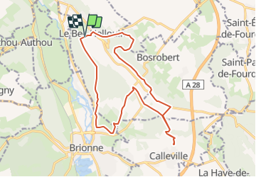

Length
16.8 km

Max alt
144 m

Uphill gradient
342 m
Km-Effort
21 km

Min alt
48 m

Downhill gradient
341 m
Boucle
Yes
Creation date :
2019-01-15 18:50:49.314
Updated on :
2022-04-09 17:11:41.801
2h12
Difficulty : Unknown

FREE GPS app for hiking
 SityTrail
IGN / Geographical institutes
SityTrail Plus
The world is yours!
About
Trail Equestrian of 16.8 km to be discovered at Normandy, Eure, Le Bec-Hellouin. This trail is proposed by thle.
Positioning
Country:
France
Region :
Normandy
Department/Province :
Eure
Municipality :
Le Bec-Hellouin
Location:
Unknown
Start:(Dec)
Start:(UTM)
333837 ; 5455542 (31U) N.
Comments